Author: Richard Tilton
No corridor trails. No handrails. No mercy. Excellent scenery.
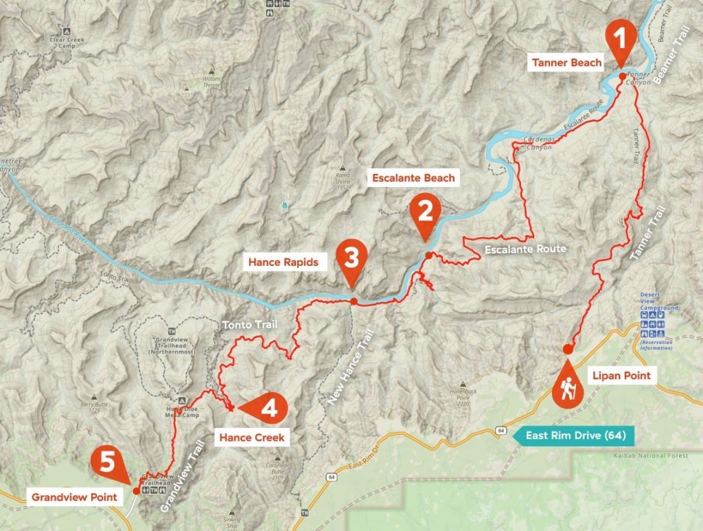
Start: Lipan Point, Tanner Trail Trailhead (7,350 ft)
End: Grandview Point (7,400 ft)
Trails: Tanner Trail, Escalante Route, Tonto Trail, Grandview Trail
Total distance: 31.3 miles
Elevation gain: 7,425 ft
Elevation loss: 7,608 ft
Lowest point: Hance Rapids 2,536 ft
Hiked: November 28-30, 2025
From the park’s description of the trail:
“Among the commonly hiked sections below the South Rim, the Escalante Route has a reputation for requiring a bit “extra” from Grand Canyon hikers. Part of the route (the Papago Wall) requires an exposed vertical climb. A feel for the route ahead will save time at the challenging spots. The Colorado River is usually the only reliable water source, so fool-proof turbid water purification methods are a necessity.
On the other hand, you will be rewarded with a variety of canyon environments, ranging from the wide-open spaces of Furnace Flats to the slot-like confines of lower Seventyfive Mile Creek. Hance Rapids at the mouth of Red Canyon represents the premier stretch of whitewater in the upper reaches of the Grand Canyon. The geology changes as the sedimentary Supergroup gives way to the ancient Vishnu Complex. They are combined with remarkable views from various elevations to produce a Grand Canyon experience of the first order.”
AllTrails description:
The Escalante route is for experienced hikers, climbers, and mountaineers. There are very technical sections of this route where rope management is recommended. It can be hiked in either direction, but this passage will be described from the perspective of a down-canyon hiker. This route leads from the Tanner Trail to the Grandview Trail.
Follow the Tanner Trail … The Colorado River via the bed of Cardenas Creek is the last reliable water source until one reaches the river at the mouth of Escalante Creek… Caution is indicated throughout this area, as there are many places where you will want to avoid a misstep.
Some sections offer a walking surface about a boot sole wide while traversing slopes that fall steeply away for hundreds of feet. Take your time and walk with care. A fine view in all directions is the reward for all the side hill walking. The trail crosses the ridge and descends rapidly…
…Walk the top of this formation around into Seventy-five Mile Creek. Enter the bed of Seventy-five Mile Creek over a fallout and continue down the drainage bottom to the river. This section of Seventy-five Mile Creek is a real treat – deep and narrow. Nevills Rapids provides a backdrop for several nice camping spots. The area is equally popular among river runners so you may encounter other groups.
The trail goes up and over a small outcrop of sandstone before dropping back to river level at the mouth of Papago Creek. Exit Papago on the west and work up a series of tall ledges. A short rope to better facilitate pack handling will prove a worthwhile accessory. Start up immediately west of the mouth of the drainage. The holds are big and secure. The route leads up from ledge to ledge, so it’s never more than a move or two between resting places if you have chosen the line of least resistance.
About 35 feet up the angle relents and one can scramble up the talus toward minor cliff bands above. There are several ways to surmount these little crags, all with obvious trails giving access. Climb the slopes to a (more or less) horizontal trail about 300 vertical feet above the river. The trail traverses less than 100 yards down the canyon before coming to the top of a talus-filled runnel that allows passage back to the shoreline. The immediate shoreline forms the most efficient route between the bottom of this little gully and the mouth of Red Canyon. The walk downstream through riparian vegetation is a real pleasure…
Reviews:
“The Escalante Route is celebrated as both the toughest and most beautiful trail in the Grand Canyon. I hiked this route and was amazed by the spectacular views of the Canyon and Colorado river I didn’t even know existed.
The trail is so rough that it officially is called a ‘route’. This means that the trail is not maintained, there is no official signage and sometimes the trail is hardly visible – or non-existent. At several passages you will use both hands and toes to proceed and there is serious exposure at short sections. No surprise that this hike is advised for experienced Canyon hikers only.” -Pieter
“If you’re looking for incredible views and an unbelievable experience, this is the trail for you. If you’re just looking for a casual backpacking trip in the canyon, this is NOT for you. Just completed this trip over 5 days, 4 nights… did not see another hiker after our first day on trail. I had completed multiple R2R2R trips prior to this and the views and campsites on the Escalante can’t be beat. With that said, don’t attempt this hike if you’re uncomfortable with heights/exposed trails along steep drop-offs. This is a fairly technical route with some serious exposure and can be a little scary at times. Highly recommend this trail for anyone looking to get off the beaten path of the corridor trails and experience the Canyon in all its glory.” -Charlie
“It’s a very HARD trail. Not for beginners or at least be prepared to suffer…. We got lost once and lost a lot of time, not always easy to find your path. Water, bring more than you think, the only place there’s water is at the bottom. The trails are not well maintained. But all this said, it’s a beautiful trail!! I’ll do it again anytime! The views are amazing. Hard but worth all the way.”
“My wife and I just completed the route in 4 days, 3 nights. It was spectacular… The slide on the other hand was extremely risky, especially at the top as you traverse under the wall. There is absolutely nothing stable on the slide. I was a bit more comfortable than my wife, but I too was extremely uncomfortable with the risk. Lowering the packs with rope would have made movement on the slide a bit better as it was quite difficult with them. This is our third backcountry trip in the canyon including the Boucher trail for reference. Unfortunately, I will never do this wonderful route again because of the risk of the slide. Sad because this is a magnificent route otherwise.” -Chris
“This is an epic hike, although not one I’m sure I’d want to do again solo. Went Lipan to Cardenas Day 1, Cardenas to Hance Rapids Day 2, and then out through Hance Creek/Grandview on Day 3. Day 3 was a lot, I didn’t get to enjoy Grandview as much as I could’ve because I was cooked.” -Kurt
“First off I want to start by saying this is not a trip but a journey it is absolutely crazy in a good and bad way. Do not attempt this hike unless you have researched and are willing to do the Papago slide others said it’s not bad I would say it was extremely dangerous and only one route doesn’t lead to injury or death. Also hiking poles are required I never used them before but if I did not have these I would have fallen off two times I’m sure if to my death as well.”
“This was a tough hike, you definitely need to have 5+ liters of water capacity and be in great shape. That said Tanner and New Hance have some of the best views you can imagine…”
“This route is an awesome way to see a large, varied section of the Grand Canyon that has very few people in it. Please, please be prepared, however, as most of it is unmaintained, unmarked, difficult, and in some key points much more difficult than you would expect on a hiking trail.” -Ken
The Easy Part
Order Date: Aug 26 2025 BC9 – Cardenas, At-Large Camping
Grand Canyon National Park Backcountry Permits Subtotal: $190.00
Making the reservation is always the easy part. Later you may ask yourself the question – “What was I ever thinking?”
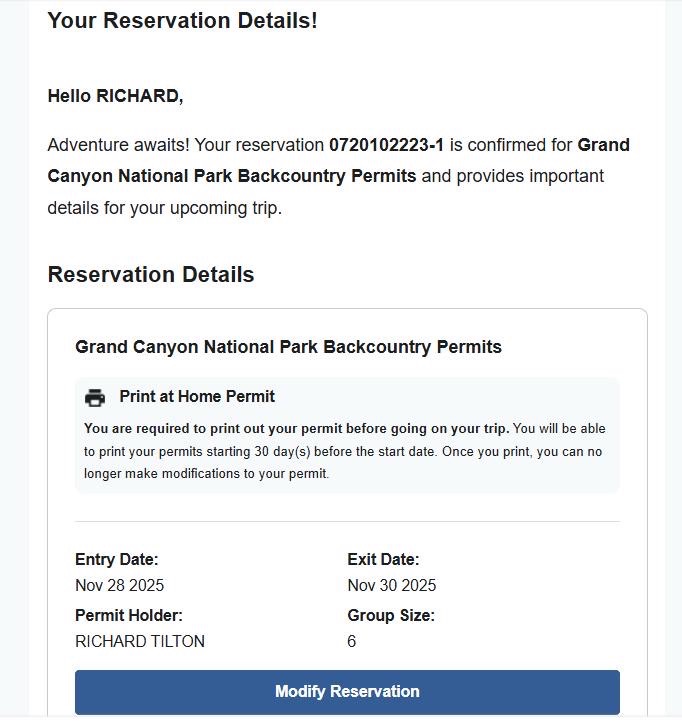
There were 6 of us.
Meet Zach. He’s the youngest at 21. He sort of ran out of time to train. He was GOING to, but he was kind of busy. He ended up training for the hike on Wednesday evening during a rain storm. Stout and blessed with the strength of youth, he’s a nice guy to have around when you have something heavy to lift. He didn’t deign to show any strain along the trail, but his eyes kind of crossed once when I asked him to carry some extra gear.
Dwight is second up in his mid thirties and managed a training routine quite similar to Zach’s. He was by far the most genetically suited for this hiking business. At home he chases a handful of rugrats and runs a bike shop. Tall and lanky, his legs really ate up the trail. Kind almost to a fault, he was always looking after the rest of us.
The rest of us had to work for this.
Lonnie is third up and still notably under forty. A talented school teacher from California (currently) with a finely tuned sense of humor. He’s also an avid fisherman. When he sees water, he’s thinking about how to fish it. Getting into shape, He’s logged literally thousands of miles out walking on the flat over the last few years, but he will be the first to tell you that does not translate well into vertical movement. I knew Lonnie was a generous guy, but he also took that almost to a fault when he offered to give some of his gear away before the hike up out of the canyon.
Suffice to say the rest of us are under 50.
Darwin is an old pro in the canyon, having done a good bit more hiking there than the rest of us. He told me he was bumping 200 lbs but I have no idea where he stores it. Obviously not where I can see it. He enjoys staying active and he eats up miles with little comment. He’s always game for an excursion and is also one of those who’s always looking out for the underdog. If there was a “backbone of the group”, it was Darwin
Charles provided the enthusiasm. Enthused about training. Enthused about the trail. Enthused about his gear. Enthused about his gadgets. Enthused that he had the lightest pack (until we loaded him up with some of our gear). Enthused to carry some of our gear. Enthused about keto. Enthused about steak (yes he carried steak, and yes I was slightly jealous). Enthused about eggs (eaten slightly earlier than planned because they were broken). Enthused about butter ( I almost went into cardiac arrest just looking at it). We made him grill the rest of us some steak after we got out of the canyon (he was enthused about that too).
And myself. The guy with the heaviest pack. (I didn’t want to be cold.) (I didn’t want to be hungry.) (I didn’t want to be uncomfortable.) (I had plenty of room in my 3 man tent.) (Dehydrated meals are expensive.) (I need a first aid kit to treat the blisters I get because my pack is too heavy.) I was also probably the one of us most bothered by heights and was glad to suggest Charles go first at the scariest section. Not that he was expendable, but I was carrying the permits and we couldn’t lose those..
Three Days on the Tanner–Escalante–Grandview Route
A rugged canyon traverse with questionable choices and outstanding views..
The Grand Canyon does not ease you into things. You know when you get to the rim, and you know when you drop over it. There’s no warm-up, no gentle introduction, and a fairly narrow window of “Can-I-really-carry-40+-pounds-for-three-days-or-should-I-chicken-out?” It’s very few hours in and down that you know you’re not going back. You’re committed now.
We didn’t know it yet, but this was to be one of the most beautiful journeys we had ever taken. Grandiose nearly to absurdity, the more familiar central canyon trails hardly even hint at what you will find here. The trails are Spectacular. Intimidating. Rugged. Exhausting. They do unexpected things. Go unexpected places. And, despite all of this, deliciously delightful.
Day 1: Lipan Point to Cardenas Creek
I don’t know.. I’m not going to spend a lot of time trying to describe specific details of the trail. You can read descriptions and look at photos until you’re blue in the face, but it simply doesn’t capture it.
We must have started down around 9:00. Sunset in late November falls shortly after 5:00, so we had about 8 hours to cover the roughly 10 miles to camp. If you are an experienced hiker, you know down can be difficult in its own kind of way. Some argue it is more difficult than up. The legs begin to shake and visibly tremble. They give you the feeling they may buckle under your next step. Just a few miles in, Lonnie’s flatland legs began an early betrayal and it wasn’t long before he knew that completing this hike (if he completed it) was going to be one of the hardest things he had ever done.
We stopped a half mile or so before we got to the Cardenas camping area. We had heard that it was overrun by backpack chewing, food stealing rodents. So we slipped into a little wash by the river and set up camp. In my mind, I sort of figured we would set up camp and then gather around and fix our food and eat together, visit, stare up at the stars, contemplate on deep and meaningful things. At the proper moment, we would nod imperceptibly and all slip off quietly to our bedrolls.
What really happened was every man for himself.
Charles wasted the least time. Before my tent was even up, he had this fancy little campstove whipped out and was melting a wad of butter in his 3in1 ultralight skillet/stockpot/teakettle. Out of his pack came one of the biggest steaks I’d ever seen. It was a well marbled ribeye, and my eyes bugged slightly as he submerged it in the sizzling butter. As if it wasn’t already enough food and fat to put a grizzly into hibernation, Charles fried a few eggs (more butter) to chase it down. At some point he explained to us how very healthy this was and the rest of us ended up feeling guilty for the occasional piece of lettuce we had snuck into our diets.
We all straggled around setting up tents, laying out bedrolls, filtering water, cooking, eating, making coffee, etc. A general melee with no choreography whatsoever. Dehyderated, re-hyderated ultralight meals ruled the evening. I sat in the privacy of my tent and quietly ate the cold, heavy stew I had packed down. I was the only one that had cold food, and to top that off, it had carrots in it.
We got our water from the Colorado river. We had heard that the river could be turbid and muddy, but it was a beautiful clear turquoise. We ran it straight through our filters and dropped in water treatment tabs. It was good water.
It was getting cooler, so we discussed what time we wanted to head out and how far we would try to get tomorrow. By this time we knew Lonnie was struggling a bit and that the next two days would be big days.
The stars were beautiful. It was crystal clear out and it got COLD. I woke up sometime toward morning and wished I had slept fully dressed. It was 36* outside.
Day 2: Cardenas Creek to Hance Rapids
I must have been the coldest one, because I was the first one up. I don’t remember what time we had decided to get on the trail, but that time was approaching and no one was stirring, so I took it upon myself to wake everyone up. This was probably an hour before we wanted to leave and it should have been plenty of time, but 2 hours later we were still breaking camp.
Later I wondered if it had something to do with our wives not being there. I mean, it takes our wives forever to pack up and get ready when we are with them – we usually wait on them. But I decided that’s probably ok – It’s even more awkward when we have to pack it up ourselves.
I stared in speechless amazement as Charles REPEATED the entire giant butter steak and eggs maneuver for breakfast. He must have a digestion of iron. My supper would have still been in the back of my throat. He figured if he ate enough in camp, he wouldn’t really need to eat during the day. Seemed to work for him, but if I had tried that, you probably would have had to roll me into the closest gully and put me out of my misery.
We eventually got moving. We were to follow the river down 10 miles or so to Hanse Rapids. Some were asking about water and I told them they didn’t need to carry much because we would be close to the river all day. This got thrown back at me a few times by the time we got back to the river 6 tough miles later. Between us, we had enough water, but we were about to go dry.
Here’s another excerpt:
“Day 2 is where the Escalante Route earns its reputation. This is not a day of big climbs or descents — it’s a long, exposed traverse that keeps you mentally engaged from start to finish.
The trail climbs away from the river early, immediately delivering one of the best views of the entire trip. Looking back, the Colorado bends through the canyon far below, framed by massive walls that feel almost theatrical. It’s a “wow” moment, quickly followed by, “Okay, eyes back on the trail.”
The Escalante Route is narrow in places and tilted in many others. It often feels less like a trail and more like a suggestion scratched into a steep slope. The exposure is constant. Not terrifying — but persistent. The kind that keeps your brain gently humming all day.
There are multiple spots where the trail rounds a corner and suddenly opens up into space. You stop. You stare straight down. You mutter something like, “Well, that’s impressive.” These viewpoints are jaw-dropping in the most literal sense — big drops, endless depth, and the river impossibly far below.”
We loved most of it, but Lonnie, while still maintaining good humor and bad jokes, was obviously not having an easy time of it. The vertical functions of his legs weren’t really working. We lightened his pack a little along the way as the rest of us took turns with a bit of the gear. I must have been feeling slightly uptight, because I got almost mad at the trail for detouring so far back up the canyon. We were more than a mile away from the river at some points. A good ways up too. Like, honestly people, our plan was to hike out tomorrow and we don’t need all this strain today. We just have to climb all the way back down to the river again. Do you even know how to build a trail?
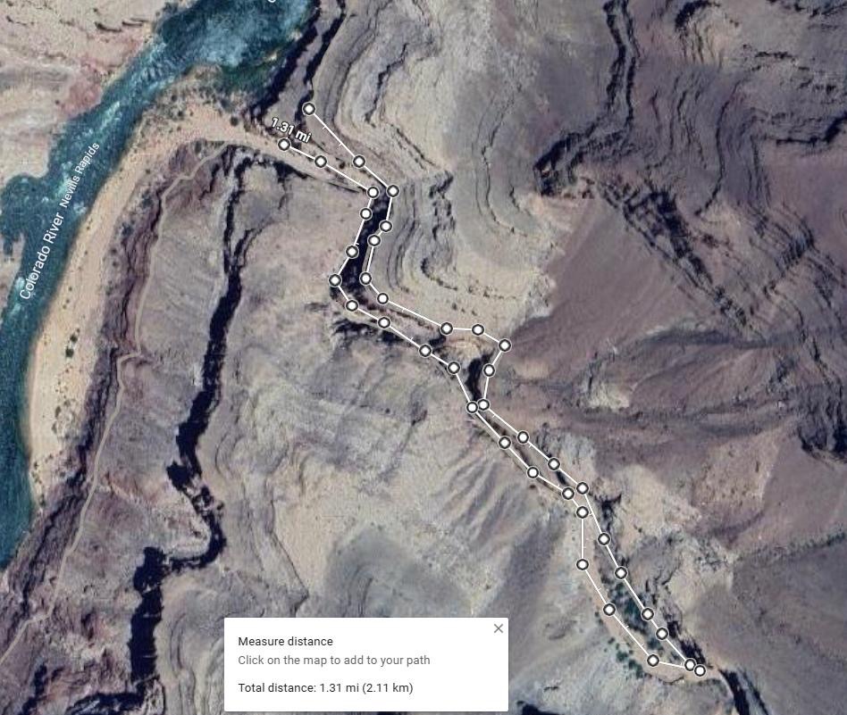
We did get back down to the river for a very late lunch. We stopped for a while but I never really had time to rest. By the time I had filtered water, scarfed down a sandwich (a giant summer sausage wrapped in a pita), and taped my blistered feet up, it was time to move on. And back up. Again. It wasn’t long and we were .65 miles away from the river again. But here we dropped back into a deep little slot canyon and followed it straight back to the river. We hiked 1.3 miles to get exactly 200 ft down river.. This was one of my favorite parts. It was epic.
By now we were getting a bit focused. We were racing to get to the Papago Wall and Slide before dark. Well, no one watching us would have known we were racing, but we knew.
None of us had been here before but we had read about this section. You have to climb a small cliff, then scramble up a loose section, pop over the top through a fat man’s squeeze, then slide a few hundred feet back down to the river through this super steep and unstable rock slide where there is a very real danger of coming down in an avalanche.
We wondered at every bump and corner if we were there yet, but the trail just kept going. We finally got there shortly before dark. The cliff up was actually easy and fun. The rest of the scramble up was fine too except for a bit of a tight spot at the top. Lonnie ended up getting stuck in the fat man’s squeeze. Not literally stuck like a cork in a bottle, not like Pooh bear after too much honey, but stuck with mental and physical exhaustion. All of his bravado had disappeared. Gone was the Lonnie that had tottered along the edges of the highest cliffs to torture those of us who suffered from vertigo just watching him.
There was a ledge at the top of the squeeze that had to be climbed over and it was just too much. It was past sunset by now and 3 of us had gone ahead to scout the slide in the last of the twilight. Meanwhile, Lonnie passed the lowest point of the trip. His head went down onto his arms on that ledge and he couldn’t go another step. Well, like I mentioned, Zach and Dwight are great guys to have around when you need a lift or a kind word. Lonnie dug in too for that extra bit of grit and by the time they caught up with us at the slide, the moment had passed.
This is where I kindly allowed Charles to go first. We tried to space out enough so that the one below had time to dodge the rocks the next one kicked down. Charles made this look easy and navigated down without turning a hair. I went next and I made it look super hard. I took a wrong turn and was the next one to nearly freeze up as I got stuck on a steep spot. I was really scared and shaky there for a minute. I was a bit preoccupied with my own journey there for a bit, but everyone made it down safely just as pitch dark closed in. We were less than a mile from camp now, and we walked the rest of the way through the brush along the river using our headlamps.
Really it was probably only 6:30 or so when we made it to camp, but we were tired. It had been a big day. But we all knew tomorrow would be an even bigger day. 11 miles river to rim. Our thoughts ranged from mildly worried to impossible as we called a powwow and made a plan. But at this point you just go ahead and plan, because there really is no other option. We have to get out. The mood was still light as we set up our tents, ate our suppers, and filtered tomorrow’s water from the beautiful green-blue Colorado river. While most of us ate, we were treated to the sight of someone in their long underwear trying to dry their sweat soaked pants over one of those itty-bitty camp stoves. It was a slow, painstaking process that involved occasionally catching the pants on fire and burning a few holes in them. Quality entertainment there..
It was supposed to be even colder tonight, nearly freezing, so I left all my clothes on and crawled into bed with an extra large set of “Hot Hands” heaters. We really did have to get going earlier tomorrow.
Day 3: Hance Rapids to Grandview Point
Hot chocolate is about the most wonderful thing you can imagine on a cold, early morning like this. Really thoughtful of you guys.
I did a complete double take when I took my first glance at the river that morning. The beautiful clear water of the last two days was gone. The river was now brown and foreboding. Muddy. Dirty. Ugly. I had never seen the river like this before. The complete transformation was amazing. I have no idea what caused it. I was thinking of topping my water off, but changed my mind. I could wait.
We didn’t mince around Lonnie this morning. It was a sober group that gathered around as Lonnie piled all of his gear in the center of the campsite. Yesterday had been tough but in all reality, we had still been going down. Yes, up and down, but down down. Net elevation gain zero. Minus actually. Today we needed to climb out. We all knew by now that we needed to lighten Lonnie’s load, so everything was taken out of his pack other than his remaining food and a couple liters of water. He was humble enough to let us do it. If we had placed bets right then whether he would make it out today or not, odds may have been 50/50, with his bet going the lowest. Charles silently loaded up the heaviest items, and the rest of us took what we could.
These kind of things are not like one might first think. We all knew before we took off that it could be challenging. We all knew that it could have been any one of us struggling. You can take a fall, turn and ankle, twist a knee, get sick from the water, anything really. You don’t always know who’s going to struggle on a deal like this. But here’s the interesting part – these are the kind of things that bring a group together as a team. We’re in this together now.
It’s a bit of a paradox. Who do you end up admiring more? Someone that completes something that is easy for them? Or someone that attempts and completes something that is extremely difficult? It was easy to see that it was going to be hard for Lonnie, but personally, I wasn’t all that worried. Yet. Lonnie is a real brick, I’ve traveled with him a few times. I’ve known him to attempt and complete a few other serious challenges. I figured that anybody that had the grit to challenge themselves to walk 100 extra curricular miles in a week and then do it, probably had what it takes to get themselves out of a canyon.
A person sometimes envies those that perform things with ease and aplomb, and you would think you would tend to scorn the weak. But in reality, you end up admiring those that struggle and win. And Lonnie did win, but he had plenty of opportunity to question before the day was done.
After a short memorial service for the rest of the gear that wasn’t going to make it out, we had a prayer together and set out.
The Grandview Trail is honest about what it is. It goes up. Aggressively. Early. Often.
From the river, the climb starts immediately. The first stretch gains elevation fast, and looking back shows the Colorado shrinking quickly below. But in this case, not quickly enough. Even with the lightened load, we were soon calling halts and rest breaks. A little bit of unwelcome math told us we were not going to make it out on time at this pace. But when legs don’t work, legs don’t work. There was nothing we could do but grind on as fast as we could.
Well there was one thing we could do and we did it with vigor. We made sure Lonnie ingested a steady flow of liquids and calories. We didn’t allow anything into his mouth that wasn’t full of carbs, sugar, caffeine, and energy. We kept his mouth full as much as possible. This accomplished two things: kept him fueled and slowed down the corny jokes. We plied him relentlessly. His eyes would beg for mercy as we shoved another cookie at him, but he was a real sport and did a super job of putting that stuff down. That had been part of the problem that had brought this on in the first place. He hadn’t eaten and drank enough the first couple of days.
After the first grueling hour or two, the trail leveled out for a while. About the same time Darwin pulled a package of Tailwind out of his pack and slipped it into Lonnie’s drink. The combination of those two factors lit a fire under Lonnie. He was back on level ground where he knew how to move. We shot through the next couple of miles at a pace that left some of us straggling.
The trail turned vertical again and we ground slowly back to a crawl. But hope had been restored. The low points were behind us (literally). Our day’s average time at that point would have had us up in pretty good time if we had maintained it. We didn’t maintain it, but we now believed we would make it out.
About this time, we took all the rest of the weight out of Lonnie’s pack. Just a few pounds of food and water had been left in there, but at this point we needed every edge we could get.
The exposure was pretty constant through the rest of the route. Exposure here meaning that you were exposed to a certain amount of risk. A slip or a stumble off the side of the trail would have sent you plummeting down. Fatally. The trail is solid but narrow in places, and vertigo makes you a bit dizzy if you look around too much. The flip side of this being up high business is that the views stay amazing. I stumbled once when I was staring around too much. I wouldn’t say I almost fell, but it was enough to really make my stomach lurch.
Hanse spring is a beautiful respite and a great place to have lunch. Water starts trickling out of the ground as you walk down the stream bed. Soon there was a tiny stream where we could put a suction line in between a couple of rocks and pump water out to fill our bottles. There were trees and shade and bigger collecting pools if you walked down a little lower.
Distance wise, we were well over halfway out, but most of the vertical distance remained in front of us. From here we settled into a bit of a routine. Grind up. Stop. Rest. Repeat. This is probably the most stunning part of the trail. Several old mines add to the interest. So many times you turn around and just say WOW quietly under your breath.
At one point while we were stopped for “long rest” (packs off), a fast hiker blew by us on his way up. As he quickly disappeared up the cliff face in front of us, Lonnie watched him morbidly and then saluted him. We must have let his mouth go empty, because he managed to get a really funny joke out.
It was with good humor that we went straight up the next cliff and continued our journey out. The trail flattens out next through the mining mesa and a few trails run together here. After the mesa, the trail is more maintained, but steep the rest of the way up.
It was dark well before we were up, but the moon was pretty bright. I didn’t bother getting my light out and a moonlight climb was a beautiful way to finish. I went ahead at the last to get internet service at the top. We already knew we had missed Lonnie’s 9pm flight out, so I was checking rebooking options. There was another flight out at 11:00pm and if we hurried we could make it. Lonnie was still scheduled to teach tomorrow. I jogged back down to meet the crew and encourage them along, but there was one functioning pace that really couldn’t be messed with.
We made it up and we made it out and we even made it to the airport. One of the ladies met us with the rest of Lonnie’s luggage, and he even had time to freshen up a little in the airport bathroom. He was a little afraid of emptying the plane otherwise. Charles grilled the rest of us late night steaks back at the airbnb and we crawled into bed for a few hours before our early morning flights out.
I’m aching to go back as I write this so hit me up if you have a couple extra permits. My envious wife will be joining me next time. I don’t plan on getting into any kind of habit of doing this kind of thing without her.
I’ll finish up quoting an ending from another description:
Difficulty, Exposure, and General Shenanigans
This is a hard hike, but not because of technical climbing. It’s hard because:
- The exposure is constant
- The terrain is steep and unforgiving
- The packs are heavy
- The canyon does not care about your feelings
That said, it’s also incredibly rewarding. If you’re comfortable with exposure, have solid route-finding skills, and enjoy earning your views the hard way, this route is unforgettable.
Final Thoughts
The Tanner–Escalante–Grandview route is serious terrain wrapped in absurdly beautiful scenery. It’s the kind of hike where you alternate between awe and mild disbelief that this is actually the trail.
You’ll laugh, you’ll sweat, you’ll stare into space more times than you can count. And long after the soreness fades, you’ll remember standing on narrow ledges high above the Colorado, wondering how something so vast can feel so personal.

Leave a reply to janalw7485f98ead Cancel reply